
Fichier:Near east lrg.jpg

Kiɖe tɛɛ takayaɣ (Kpaɣna pɩkɩsɛlɩ 2 987 nɛ pɩtalɩ 3 967 ñɩŋgʋ, takayaɣ walanzɩ : 2,62 Mio, MIME akɩlɩ : image/jpeg)
| Kɛdɩtʋ |
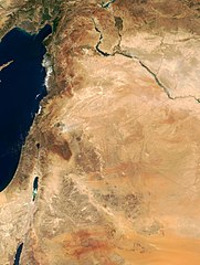
This true-color image of the region was taken on September 10, 2000, by the MODerate-resolution Imaging Spectroradiometer (MODIS) flying aboard NASA's Terra spacecraft. The image shows the lands of Israel along the eastern shore of the Mediterranean Sea, with the countries of Jordan to the southeast and Syria to the Northeast. The region known as the West Bank lies between the two countries. Running from north to south, the Jordan River links the Sea of Galilee to the Dead Sea. Click the image to enlarge it, and to see the borders drawn in. Image courtesy Jacques Descloitres, MODIS Land Group, NASA GSFC |
| Efemiye | image taken on 10. Sep. 2000 |
| Kiɖe | http://earthobservatory.nasa.gov/Newsroom/NewImages/Images/modis_near_east_lrg.jpg |
| Mayʋ | NASA, earthobservatory, http://earthobservatory.nasa.gov/ |
| Waɖɛ haʋ (Ɖaɣnʋʋ labɩnaʋ takayaɣ kanɛ) |
PD-USGov-NASA |
| Ce fichier provient de la NASA. Sauf exception, les documents créés par la NASA ne sont pas soumis à copyright. Pour plus d'informations, voir la politique de copyright de la NASA. | ||
 |
Attention :
|
Takayaɣ caanaʋ tɔm kɛdʋʋ
Tukina efemiye nɛ ñɩɣtʋ nɛ ŋna takayaɣ kanɛ ɛzɩ kaawɛʋ alɩwaatʋ ndʋ tɩ-taa yɔ.
| Efemiye nɛ ñɩɣtʋ | Tampɔɔ | Walanzɩ | Labɩnayʋ | Tɔm taa nuutuu | |
|---|---|---|---|---|---|
| lɛlɛɛyɔ | 5 Lɛlaɣ fenaɣ 2015 à 20:27 | | 2 987 × 3 967 (2,62 Mio) | Capricorn4049 | Cropped < 1 % horizontally and 1 % vertically using CropTool with precise mode. |
| 5 Mɩsɩkʋm fenaɣ 2005 à 09:29 |  | 3 002 × 4 002 (1,96 Mio) | Prolineserver | near east, PD-USGov-NASA |
Takayaɣ labɩnaʋ
Takayɩhayʋʋ kɩtɩŋʋʋ lakɩna takayaɣ kanɛ tʋmɩyɛ :
takayaɣ labɩnaʋ nɛ paa anɩ
Wikinaa kɩtɩŋaa lɛlaa lakɩna kɩlɛmʋʋ kʋnɛ nɛ tʋmɩyɛ :
- Labɩnaʋ ar.wikipedia.org yɔɔ
- Labɩnaʋ arz.wikipedia.org yɔɔ
- Labɩnaʋ ast.wikipedia.org yɔɔ
- Labɩnaʋ ba.wikipedia.org yɔɔ
- Labɩnaʋ ca.wikipedia.org yɔɔ
- Labɩnaʋ ckb.wikipedia.org yɔɔ
- Labɩnaʋ el.wikipedia.org yɔɔ
- Labɩnaʋ en.wikipedia.org yɔɔ
- Labɩnaʋ eo.wikipedia.org yɔɔ
- Labɩnaʋ eo.wikiquote.org yɔɔ
- Labɩnaʋ es.wikipedia.org yɔɔ
- Labɩnaʋ eu.wikipedia.org yɔɔ
- Labɩnaʋ fa.wikipedia.org yɔɔ
- Labɩnaʋ fr.wikipedia.org yɔɔ
- Labɩnaʋ gl.wikipedia.org yɔɔ
- Labɩnaʋ he.wikipedia.org yɔɔ
- Labɩnaʋ id.wikipedia.org yɔɔ
- Labɩnaʋ is.wikipedia.org yɔɔ
- Labɩnaʋ it.wikipedia.org yɔɔ
- Labɩnaʋ ja.wikipedia.org yɔɔ
- Labɩnaʋ ko.wikipedia.org yɔɔ
- Labɩnaʋ mk.wikipedia.org yɔɔ
Cɔna takayaɣ labɩnaʋ tɩŋa